

Welcome back to The CP Journal, where we break down what it takes to get left of bang.
Earlier this week, I shared that I’ve joined Ladris as a Strategic Advisor.
It’s a company developing technology that I believe has the potential to meaningfully change how public safety agencies prepare for and respond to emergencies.
I wrote more about why I joined the company in that announcement, but for this week’s briefing, I want to show you one of the reasons why.
A public safety agency could recognize an emerging incident early, make the decision to evacuate a neighborhood, and get the warning out to residents well before people are in danger.
But does that mean the community has enough time to evacuate?
It’s a question that might seem relatively straightforward until you consider everything that needs to happen between recognizing a threat and getting an entire neighborhood to safety.
In last week’s briefing, I wrote about the relationship between the warning time provided by recognizing threats early and the time required for an organization to act. But there’s another challenge, and an extension of what I wrote about last week, that I want to dig into this week.
What if we don’t actually know how much time we need?
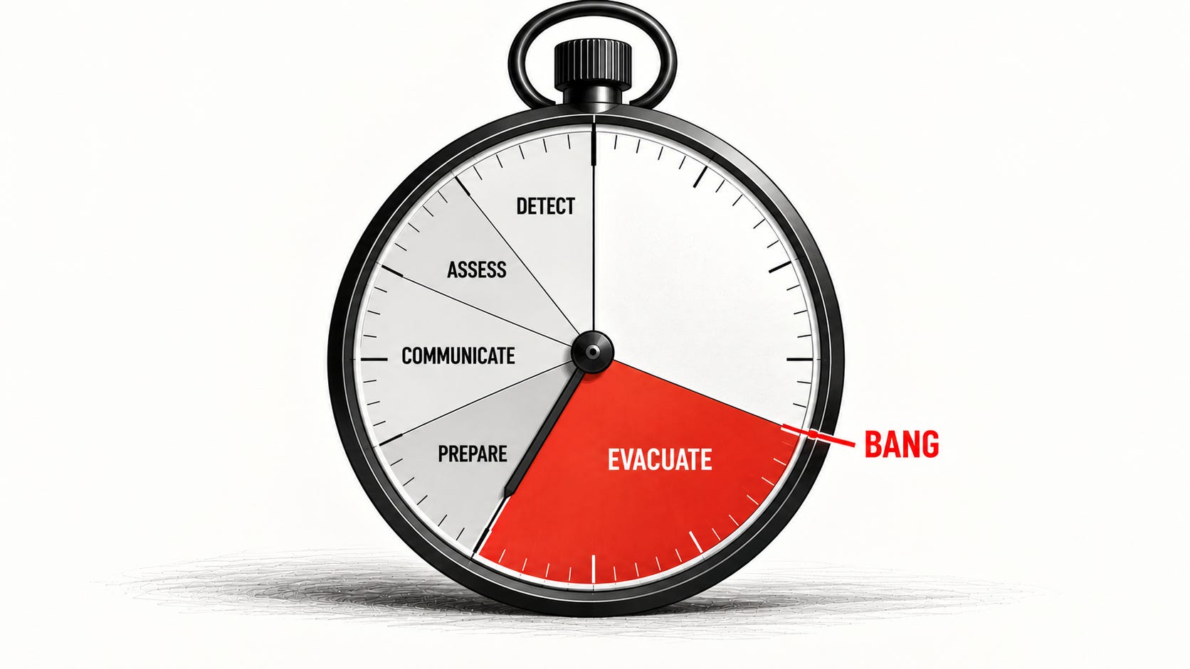
Consider the sequence of events, and the time that it takes to complete them, when evacuating a neighborhood ahead of a fast-moving wildfire:
Time to detect: There is the time it takes for someone (or monitoring equipment) to recognize that a fire has started and alert public safety agencies.
Time to assess and decide: It takes time for a public safety professional to get eyes on the incident (regardless of whether they physically travel to the site or begin that process leveraging technology) and assess the situation. They need to consider where the fire is, where it is likely to spread, what might be threatened, and whether evacuation is necessary.
Time to communicate: Once the decision is made, it takes time to communicate that decision to the community. That might involve coordinating with an alerting authority such as a 911/dispatch center, preparing the message in the alerting platform/system, obtaining necessary approvals, and distributing the warning over congested telecommunications systems. It also likely involves police officers going door-to-door to reach people who haven’t received or seen the alert.
Time to assess and prepare: Once the message reaches residents, they need time to understand what they’re being asked to do, make sense of the situation, decide to leave, gather what they’re taking with them, and get moving.
Time to evacuate: Finally, there is the time required for people to physically move from an area at risk to a location where they will be safe.
In our recent webinar about getting left of bang in the context of wildfires, we described “bang” as a fast-moving, wind-driven fire threatening people faster than we can warn and evacuate them.
Each of these five stages contributes to whether we’re able to accomplish that goal and get people out of danger in time. But even though all five of these steps deserve attention, there is a difference between the first four and the fifth one.
Improvements in technology, training, organizational processes, and community education will help reduce the time it takes to complete each of the first four steps, potentially bringing some of those activities down to seconds or single-digit minutes. They can’t go to zero, but I can’t envision a future where they aren’t better than they are today.
But the fifth step is the variable that I want to focus on. How long will it take to actually evacuate the neighborhood? Will it take 10 minutes? 50 minutes? 150 minutes?
That answer is absolutely critical to answer because it determines how early the evacuation process needs to begin and the decisions public safety professionals need to make. If a wildfire is going to reach the outer edge of a neighborhood in 45 minutes, a community that requires 90 minutes to evacuate represents a very different problem than one that can be cleared in 20 minutes.
Traditionally, an agency might have relied on a seasoned police officer’s knowledge of the community and experience during previous disasters to develop this estimate. Or perhaps there is a public works director with an impressive Microsoft Excel sheet that can provide some insight. Or maybe there is an emergency manager who remembers the results of a community evacuation exercise conducted several years earlier.
All of those sources can provide useful information, but how confident should we be in the resulting estimate?
Consider what happens when an entire neighborhood attempts to evacuate from a wildfire at once. Roads that normally accommodate routine traffic suddenly have hundreds or thousands of vehicles trying to leave in the same direction. Visibility might be reduced by smoke. Drivers are stressed, uncertain about where they are going, and understandably concerned about what they’re leaving behind.
And the answers could change considerably depending on the time of day, which roads remain available, and whether traffic control measures are in place. There’s a lot of uncertainty in that number, and that uncertainty is front and center when you’re trying to determine whether the time available to evacuate is greater than the time required to do it.
But there’s another consequence to not having a reliable estimate as well. If we don’t have a reasonable baseline for how long an evacuation could take, how do we determine which changes will actually make it faster?
And this is where Ladris enters the story, at least for me.
As I mentioned at the top of the article, I recently joined their team as a strategic advisor, but it was because of how their technology can change the way organizations prepare for and respond to wildfires and evacuations that I wanted to get involved.
The first time I saw their platform, I was working with a client to develop a new wildfire evacuation plan for their city and county, and that organization had also purchased a Ladris license to develop estimates for the time it would take to evacuate different portions of their community as part of the planning process.
And it blew me away. I could model different evacuation scenarios, adjust traffic patterns, staff traffic control points, change when people would leave their homes, and test countless other variables to develop a deeper understanding of what an evacuation could actually look like in that community.
Instead of relying solely on assumptions about how long an evacuation might take, we could establish an estimated baseline and begin testing ways to improve it. And we could do that before an incident occurred, when there was still time to make changes to plans, develop capabilities, and address problems.
Then, during a recent meeting, I had the chance to see another capability that made me even more interested in where the company is heading. Ladris has developed a platform that brings wildfire spread modeling together with evacuation modeling. Using information about weather, terrain, and vegetation, the platform can estimate where a fire is likely to spread, and how long it may take to reach different locations, and estimate how long it will take to evacuate that neighborhood.
That means agencies can compare how much time they likely have before a fire threatens a neighborhood with how much time they need to evacuate it. And they can begin making that comparison while there is still an opportunity to do something about it.
Think about the implications for law enforcement officers specifically, who often have the primary responsibility for carrying out evacuations.
Going back to our earlier example, if a model indicates that a fire could reach a neighborhood in 45 minutes, but evacuating that neighborhood is likely to require 90 minutes, that is incredibly important information for the people responsible for making decisions.
An agency that recognizes it doesn’t have enough time might begin prioritizing the most immediately threatened areas, change how it manages traffic, identify locations where evacuation routes could become compromised, and evaluate alternative protective actions for people who may not be able to reach safety in time.
Those decisions are difficult under the best of circumstances. Having better estimates doesn’t make them easy—and it certainly doesn’t eliminate the need for firefighters to assess conditions on the ground—but it does give decision-makers something more substantial to work with than an educated guess.
And importantly, it creates opportunities to act earlier. With a better understanding of how an incident is likely to develop, commanders and responders can begin preparing and initiating appropriate actions without waiting for every aspect of the situation to be fully understood.
This is what interests me so much about the application of technology in public safety.
Whether I’m speaking to people about Hazzard or Ladris, platforms like this are not simply giving professionals more information to look at. Technology like this can create opportunities for people to understand a developing situation earlier, evaluate what might happen next, and make decisions while they still have time to influence the outcome.
In preparedness, these capabilities can help organizations identify where investment in their evacuation capabilities could produce the greatest improvements. During an incident, they can help responders understand whether their available time is sufficient for the actions they’re considering.
They can help you get left of bang.
But to bring this back to where we started, there’s a more immediate lesson that doesn’t depend on having access to any particular technology. If we want to know whether our organizations can act within the time available, we need to understand how long those actions actually take.
And if we want to improve that performance, we need a way to measure it.
As we close this week’s briefing, I do have one thing to ask of the group.
I shared this week about why I joined Ladris, and I’d love for you to read that if you’re interested in learning more about the relationship.
I would also welcome the opportunity to speak with public safety professionals who are working through evacuation challenges in their own communities. My role will involve helping the company understand the operational realities of the agencies it serves and supporting how its capabilities are developed.
If you’re willing to share how your agency currently approaches evacuation planning and response, what works, and where you see opportunities to improve, I’d love to have that conversation.
Thanks for reading, and I’ll see you next week.
—Patrick